Geomatics Supervisor and Egyptian Archaeology PhD student Anna Hodgkinson told me that she is trying to apply an affine transformation to a set of coordinates. These are originally in an unknown local coordinate system. She has provided 4 reference points for which both the local coordinates and the EPSG:32636 coordinates are known: ID ; EPSG_32636_X ; EPSG_32636_Y ; Local_X ; Local_Y 1 ; 300646.885431 ; 3231905.223285 ; -144.333424 ; -50.678221 4 ; 300939.099675 ; 3232334.126771 ; 100.477740 ; 407.439814 7 ; 300519.458438 ; 3232235.904115 ; -304.216081 ; 262.236955 8 ; 300717.256565 ; 3232552.638076 ; -141.107317 ; 602.476276 First we need to compute which affine transformation takes the coordinates from the local grid to EPSG:32636. To achieve this, we can use the raster georeferencing tool in gvSIG since it lets you input by hand the source and target coordinates and then creates a WLD file whose 6 parameter...
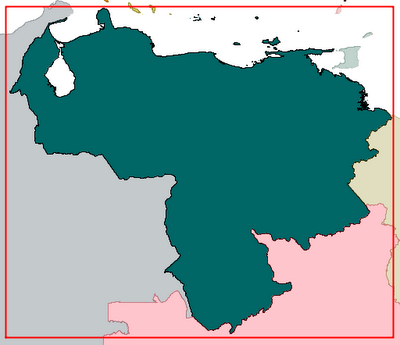
Puesto que gvSIG 1.9 no permite utilizar la transformación Molodensky-Badekas de 10 parámetros , una alternativa consiste en crear una rejilla o grilla de transformación en formato NTv2 utilizando los resultados de la transformación en un gran número de puntos de control repartidos por todo el territorio (en este caso, Venezuela). Hermógenes Suárez y José Nicolás Pérez Duin han publicado en la lista de usuarios de gvSIG una hoja de cálculo con las fórmulas y los parámetros necesarios para realizar la transformación. Para realizar la rejilla de transformación, partimos del rectángulo mínimo que contiene a todo el territorio de Venezuela: Longitud: [-73.5, -59.75] Latitud: [0.5, 12.25] La distancia entre los nodos de la rejilla debe, por un lado, ser lo suficientemente pequeña como para proporcionar una precisión adecuada, pero por otro lado no debemos generar una rejilla con un número desorbitado de nodos. En el primer intento, generaremos una rejilla con una distancia entre nodos de ...
Ojeando la web http://www.epsg-registry.org y las explicaciones de la especificación OGC WMS 1.3.0 , se deduce que las nuevas versiones de los protocolos y formatos de OGC (WMS, WFS, GML, etc) van a respetar rigurosamente las especificaciones de EPSG en lo que se refiere al orden en el que se colocan las coordenadas (es decir, si se coloca antes la X ó la Y, o bien si se coloca antes la longitud o la latitud). El resumen es este: Para CRS geográficos (coordenadas en grados) se usará siempre el orden [latitud, longitud]. Ejemplos: EPSG:4326 (datum WGS84), EPSG:4258 (datum ETRS89), EPSG:4230 (datum ED50). Para CRS proyectados (coordenadas generalmente en metros) se usará por lo general el orden [E, N], donde "E" significa "Eje en la dirección este-oeste" y "N" significa "Eje en la dirección norte-sur". Este orden es el "tradicional" que solemos llamar "X, Y". Ejemplos: EPSG:32630, EPSG:23030, etc. Excepcionalmente, algunos...

Comments
Post a Comment